
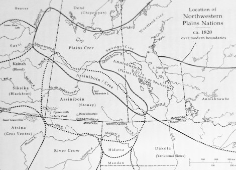
Map illustrating approximate locations of Indigenous people on the Great Plains, ca. 1820. (Map: Walter Hildebrandt and Brian Hubner)
The land that is Cypress Hills has been home to Indigenous Peoples for at least 15,000 years. Pleistocene Hunters capitalized on this area as the glaciers retreated. (1) It was left untouched as the glaciers passed on either side of this 2600 square kilometre plateau. These hills are the highest point between the Rocky and Appalachian mountains. This diverse landscape creates a distinct microcosmatic biome different from the surrounding prairies and is incredibly biologically diverse. Weather is extreme in Cypress Hills and in most years ranges from 38° C to -45° C. Despite this, a plethora of wild game including Moose, Elk, Whitetail and Mule Deer, Pronghorn Antelope, Mountain Lion, Coyote, Lynx, Bobcat, Fox and other smaller mammals and birds make Cypress Hills home. Until the late 19th Century this area was bountiful with Plains Bison, Grizzly Bear and Wolves. The last of the wild Plains Bison was shot here in 1882 on the Irvine Flats. Unfortunately, these animals were hunted to near extinction, which has had a lasting impact on both the grasslands landscape and Indigenous inhabitants. Furthermore, intensive agricultural practices have claimed nearly the entire prairies for monocultural farming practices. The only pockets of land left on the prairies are areas that are unsuitable for farming because of topography. One of the most important resources these hills still hold is the Lodgepole Pine. This tree grows incredibly straight and only has branches on its upper reaches, which makes it perfect for tipi poles and both horse and dog travois. These hills hold some of the only Lodgepole pine populations outside of the Rocky Mountains. Indigenous people believed that these hills are where the weather comes from and named them “Thunder Bearing Hills”. (1)
The cypress hills were inhabited by four bands: Piapot, Lucky Man, Carry the Kettle and Nekaneet. Removal of Indigenous people from along the border was common. Nekaneet knew that the Indian agent did not have the right to do this, nor did he have a right to say where Nekaneet and his followers were to live. He also knew that the Cypress Hills would help his people survive and prosper. Gordon Oakes- Nekaneet Band Elder.
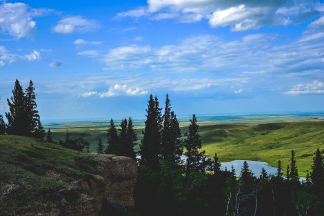
View from Conglomerate Cliffs overlooking the prairie landscape to the North. (Photo: J Surkan)
Cypress Hills was a stronghold for both First Nations and Métis people in the 19th Century. The landscape afforded an area of winter refuge from the harsh plains. It is filled with many coulees and peaks, which created localized areas of shelter where families would make winter hibernation (hivernant) camps built of temporary log homes. In the later 19th century there was over 2000 lodges in the Cypress Hills. A Coulee is the area between two hills or peaks that water drains through on it’s path to a creek and eventually a river. These areas receive more moisture than the tops of hills and often are densely forested with substantial coniferous timbers. These timbers were used to construct homes for Métis families. This helps shelter the coulee from biting prairie winds. Métis families found refuge in these coulees, and it is said at one time in history, nearly every coulee in the Cypress Hills would have been inhabited. (2) A number of families lived along the Whitemud River, near Maple Creek, SK. These families migrated to this area before 1869 from Red River. Among this group was Louis Riel’s adjutant general, Ambroise Lepine. (1) After the resistances in Red River around 1870, many families were dispersed onto the prairies and families were fractured. Many families migrated south into the United States to the Missouri River basin. Other families moved up to settlements on the Peace River in Alberta and North Central Saskatchewan in fear of being caught by the government.
“The Canadian West was never a frontier waiting to be taken or conquered. For Hundreds of years the Cypress Hills were a place of rich and varied flora and fauna that Aboriginal peoples of the prairies relied upon for their subsistence.” – Walter Hildebrandt
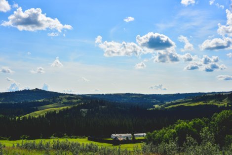
Fort Walsh sits in the foreground of this image. In the background is a coulee, a land-form that functions as a drainage. The coulee’s of Cypress Hills provided a micro-climate that sheltered Métis families from the harsh weather conditions. At one time, it is said that nearly every coulee here had an Indigenous family living in it during winter months. (Photo: J Surkan)
Mapping is an important tool in understanding the relationships of different people across time in a landscape. Part of this research project is exploring the use of digital mapping techniques to bring historical places into a contemporary time through using contemporary technology. The Cypress Hills are rich in both historical and contemporary Indigenous culture and this map is a visual way to represent this.
A digital of the Cypress Hills can be found here.
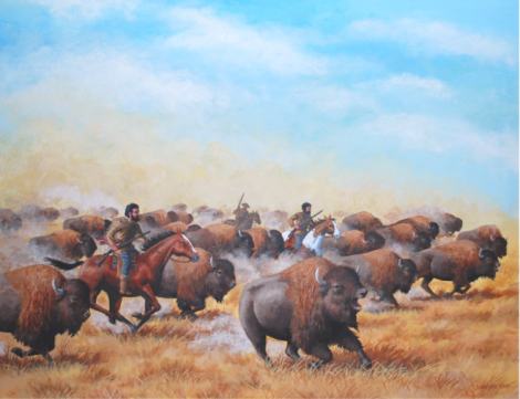
Painting of a Métis Buffalo Hunt. With the end of the Buffalo hunt in the early 1880’s, a critical shift in Métis culture ensued that has had lasting impacts on Métis societal and family structure. (Image: First Peoples of Canada)
A Family History
Royce Pettyjohn is from the Cypress Hills area, and has a long family history here and is grounded in the land. He currently works out of the Maple Creek Visitor Centre and is involved with the local Oldtimers’ Museum. Royce is a well versed historian; he worked as director at Fort Walsh for a number of years, and initiated many projects including the construction of two historical “Métis Cabins”. He has a long family history in the area of Cypress Hills, and is extremely knowledgeable regarding the Métis history of the area. Royce’s Great Great Grandfather, Henry Dumont, is a first cousin to the famed, Gabriel Dumont.

Henry Dumont’s cabin after it’s relocation to Macleod Bench. (Photo: R. Pettyjohn)
The Dumont family constructed single room log dwellings in the Cypress Hills out of local materials. These homes were built to a high standard of craft, as these homes are still partially standing over one hundred years later. The above home, is Henry Dumont’s home. It was constructed with local coniferous trees, likely pine and/or white spruce, and the corners were joined using the dovetail notching technique. This technique interlocks the logs and naturally sheds water away from the joint creating a strong connection that will last a long time. Many Indigenous families were forced to leave the Cypress Hills for the creation of a Forest Reserve by the government.
By the early 20th century nearly every coulee in the Cypress Hills had a Métis family living in it. However, when the Federal Forest Reserve was established by the Government in the early 20th century, all the Métis living within what was to become the Forest Reserve were compelled to leave. — Royce Pettyjohn
Royce’s family was forced to relocate out of the Cypress Hills to an area just outside of the Forest Reserve on the North side of the Macleod Bench. The above cabin was dismantled and moved to this area, where it still sits today. A saddle notched log addition was added on at this time and was living quarters for Henry Dumont’s Uncle, Louis Dumont. Although not mentioned on the diagram, the beds had mattresses stuffed with deer hair and the “comforter” on the top of the bed was an old buffalo robe. Area rugs on the wooden plank floor were badger skins. The original kitchen cupboard is standing inside what remains of the cabin.
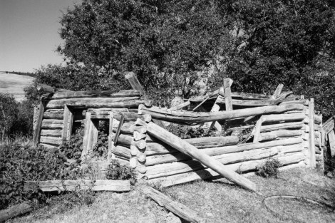
Henry Dumont’s cabin after it’s relocation to Macleod Bench. This is a recent photograph of Royce’s Great Great Grandfather’s cabin, Henry Dumont, here in the Cypress Hills as a ruin. The photo shows the later saddle notched corner addition being in very poor condition, and the dovetailed corner original section of the building being in comparatively better condition. (Photo: R. Pettyjohn)
This is a diagram that Royce’s Grandfather, Willard A. Dumont, drew of his Grandfather’s cabin (Henry Dumont) here in the Cypress Hills which is pictured above. Royce’s Grandfather drew the diagram from memory, while Royce added notes to the diagram.
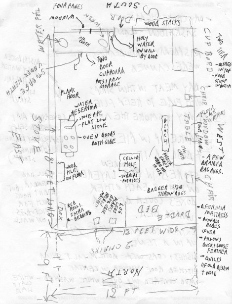
Plan of Henry Dumont’s Home. The detailed notes give insight into the domestic lifestyle of Métis families. (Sketch: R Pettyjohn)
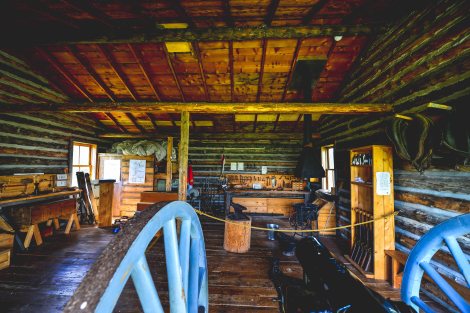
The above photographs and sketches give insight into the Dumont’s family history within the Cypress Hills region. This helps create a better understanding of the types of structures Métis people built and occupied in the region before the creation of a Federal Forest Reserve. There are many different Métis families that lived and still live in and around the Cypress Hills. Below is an image of the interior of a reconstructed Métis trading post at Fort Walsh that Royce was involved with.
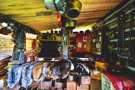
Interior of a Reconstructed Métis Trading Post at Fort Walsh National Historic Site. Royce Pettyjohn was an integral part of the team that saw construction of this cabin through. (Photo: J Surkan)
Fort Walsh
Fort Walsh sits on Treaty 4 land in the Southwest corner of Saskatchewan, near Alberta and Montana among the Cypress Hills. These hills were a stronghold for Métis people starting around 1840 as they opened up to settlement. Fort Walsh was built by the Federal Government as a strategic location in an attempt to curb illegal whiskey trading in the area. Many Métis men worked in the construction and operation of this fort. Many of the men served as indispensable scouts and guides for Fort Walsh. Many of the coulees in the area were inhabited by large Métis families These coulees create a micro climate which is sheltered and warmer than the surrounding plains. By the mid 19th century, nearly three hundred Métis families inhabited the area creating an informal community where Métis culture thrived. The buildings of Fort Walsh are built of local materials. The forest provided abundant White Spruce, Lodgepole pine and Aspen trees, which are excellent building materials. The buildings were constructed using traditional log building tools and methods.
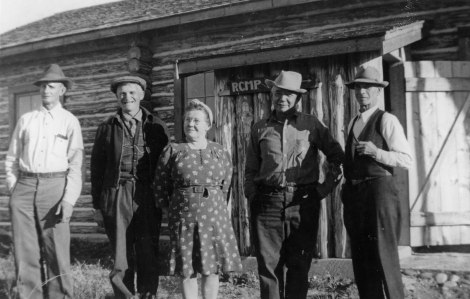
This is a photograph from the collection of the S.W. Sask. Oldtimers’ Museum & Archive showing Barney Montour outside the Superintendent’s Residence at Fort Walsh in the 1940’s. Barney lived up the coulee behind Fort Walsh and served as a contractor for the RCMP in reconstructing the log buildings at the fort. The photo of a cement footing has “B. Montour RCMP 1944” carved into it from when Barney constructed the building. This was discovered under the Superintendent’s Residence when the building was rehabilitated by Parks Canada in the late 1990’s. (Photograph: Oldtimers’ Museum and Archive)
Contemporary Métis Community
Cypress Hills has a rich history of Métis presence and architecture which makes it an important region for Prairie Métis history. It has direct ties to both the Red River and Batoche settlements as an area where disenfranchised Métis families sought refuge from government persecution. There are many Métis families living and working in the area presently. I want to sincerely thank Royce for his generosity, knowledge and time given in meeting with the project team. His families historical work is important insight in Prairie Métis architectural history. I would also like to thank Donny White for his contribution to this research and time.
Fort Walsh, SK. (Photo: J Surkan)
References:
(1) Hildebrandt, Walter, and Brian Hubner. The Cypress Hills: the land and its people. Saskatoon: Purich Pub., 1994.
(2) Interview with Royce Pettyjohn.
